Dealing with spatial misalignment to model the relationship between deprivation and life expectancy: a model-based geostatistical approach
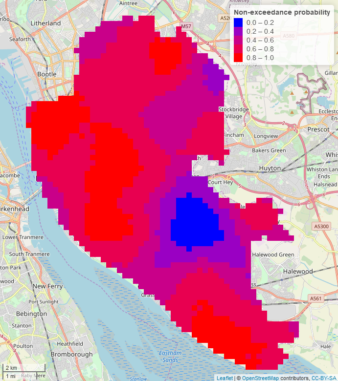 Maps of the non-exceedance probability of female life expectancy at birth (LEB), with threshold 82.9 in Liverpool, UK
Abstract
Life expectancy at birth (LEB), one of the main indicators of human longevity, has often been used to characterise the health status of a population. Understanding its relationships with the deprivation is key to develop policies and evaluate interventions that are aimed at reducing health inequalities. However, methodological challenges in the analysis of LEB data arise from the fact that different Government agencies often provide spatially aggregated information on LEB and the index of multiple deprivation (IMD) at different spatial scales. Our objective is to develop a geostatistical framework that, unlike existing methods of inference, allows to carry out spatially continuous prediction while dealing with spatial misalignment of the areal-level data. We developed a model-based geostatistical approach for the joint analysis of LEB and IMD, when these are available over different partitions of the study region. We model the spatial correlation in LEB and IMD across the areal units using inter-point distances based on a regular grid covering the whole of the study area. The advantages and strengths of the new methodology are illustrated through an analysis of LEB and IMD data from the Liverpool district council. We found that the effect of IMD on LEB is stronger in males than in females, explaining about 63.35% of the spatial variation in LEB in the former group and 38.92% in the latter. We also estimate that LEB is about 8.5 years lower between the most and least deprived area of Liverpool for men, and 7.1 years for women. Finally, we find that LEB, both in males and females, is at least 80% likely to be above the England wide average only in some areas falling in the electoral wards of Childwall, Woolton and Church. The novel model-based geostatistical framework provides a feasible solution to the spatial misalignment problem. More importantly, the proposed methodology has the following advantages over existing methods used model LEB: (1) it can deliver spatially continuous inferences using spatially aggregated data; (2) it can be applied to any form of misalignment with information provided at a range of spatial scales, from areal-level to pixel-level.